It took two attempts on two different days and my trusty GPS (Greg Positioning Satellite) to get us to Hovenweep, a Paiute and Ute word meaning “Deserted Valley”.

Hovenweep (Deserted Valley)

Hovenweep
In retrospect, it wasn’t that difficult….you simply take the “G” Road (never mind that this two lane country route is unmarked and about 30 minutes later, follow the arrow on the brown Hovenweep sign. No matter what, don’t turn back (our mistake on day one). On the way back…don’t go the way you came. Take the two-lane “10” Road to the unmarked intersection and let your GPS guess which road to take. One big successful loop!

Quite the Rainy Day
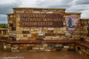
Square Tower Visitor Center
The Hovenweep National Monument covers a 20-mile area of mesa tops and canyons in Utah and Colorado. Located 42 miles from Cortez, CO and 45 miles from Blanding, UT, it preserves ancestral Puebloan dwellings built on canyon rims and boulders.
Imagine….
….Ancient Times
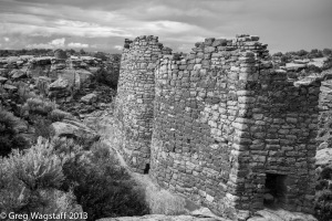
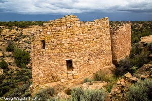
We visited Square Tower area, one of the six monument areas. Most are remote and only accessible by dirt roads (weather permitting) but Square Tower is easily accessible. Not as grand or well known as Mesa Verde, but a jewel!


An easy, 2-mile walk presents close-up views of the dwellings. It seems to me that Hovenweep, a bit off the beaten path, abandoned by its early inhabitants and undiscovered by many tourists, remains….. a deserted valley.


Gotta get me one of them GPS’s. Can Greg do the english lady voice?
LikeLike
He’s working on it but sounds more like Mrs. Doubtfire!
LikeLike
I thought GPS stood for “Greg, Positively a Stud”.
LikeLike
Yep! That too!–R
LikeLike
you sure have some creative followers…..
LikeLike